Property Record
303 Main St, West Point, VA 23181
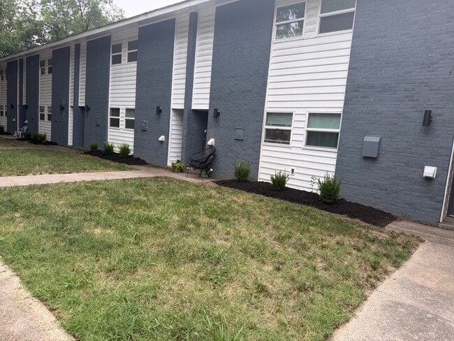
This Property Is For Sale
NEARBY LISTINGS FOR SALE OR LEASE
-
-
View all West Point listings for sale on LoopNet.com
Property Detail
303 Main St
Richmond, VA
Town Of West Point
69A1-14-158
D ST LOTS 154 155 & 156 4TH AND MAIN STR EET
Ruralagriculturalresidence
King William
X
Virginia
51101C0293F
154
2025
0.13 AC
2025
King William County
950200
Richmond VA
1,911 SF
DEMOGRAPHICS near 303 Main St
1 Mile
3 Mile
5 Mile
2024 Total Population
149
4,961
6,818
2029 Population
150
5,263
7,281
Pop Growth 2024-2029
+ 0.67%
+ 6.09%
+ 6.79%
Average Age
42
42
42
2024 Total Households
61
1,888
2,582
HH Growth 2024-2029
0.00%
+ 5.67%
+ 6.35%
Median Household Inc
$67,500
$88,493
$90,663
Avg Household Size
2.40
2.50
2.50
2024 Avg HH Vehicles
2.00
2.00
2.00
Median Home Value
$272,222
$284,439
$289,194
Median Year Built
1965
1976
1980
Nearby Places
- Restaurants
- Banks
- Shops
- Fitness
- Groceries
PUBLIC TRANSPORTATION
AIRPORT
Richmond International
DRIVE
WALK
Distance
Richmond International
43 min
33.6 mi
Freight Ports
Virginia Port Authority - Richmond
DRIVE
WALK
Distance
Virginia Port Authority - Richmond
56 min
42.9 mi
Nearby Properties
Address
Land Use
TOTAL SIZE
Lot Size
Zoning
Address
Land Use
TOTAL SIZE
Lot Size
Zoning
85,500 SF
42 AC
R-1
Address
Land Use
TOTAL SIZE
Lot Size
Zoning
4,888 SF
362 AC
INDUSTRIAL
Address
Land Use
TOTAL SIZE
Lot Size
Zoning
81,780 SF
11.38 AC
MU-1
Address
Land Use
TOTAL SIZE
Lot Size
Zoning
12,960 SF
8.24 AC
M-2
Address
Land Use
TOTAL SIZE
Lot Size
Zoning
357.24 AC
EO
Address
Land Use
TOTAL SIZE
Lot Size
Zoning
1.30 AC
M-2
Address
Land Use
TOTAL SIZE
Lot Size
Zoning
7,188 SF
6.67 AC
BUS
Address
Land Use
TOTAL SIZE
Lot Size
Zoning
5,400 SF
15.32 AC
M-1
Address
Land Use
TOTAL SIZE
Lot Size
Zoning
7,560 SF
9.89 AC
IND
Address
Land Use
TOTAL SIZE
Lot Size
Zoning
4,026 SF
6.93 AC
BUS
Address
Land Use
TOTAL SIZE
Lot Size
Zoning
8,181 SF
7 AC
INDUSTRIAL
Address
Land Use
TOTAL SIZE
Lot Size
Zoning
11,732 SF
10 AC
GENERAL BU
Address
Land Use
TOTAL SIZE
Lot Size
Zoning
310.75 AC
A1
Address
Land Use
TOTAL SIZE
Lot Size
Zoning
8,400 SF
30.50 AC
INDUSTRIAL
Address
Land Use
TOTAL SIZE
Lot Size
Zoning
4,198 SF
2.15 AC
BUS
Address
Land Use
TOTAL SIZE
Lot Size
Zoning
18,853 SF
4.89 AC
M-1
Address
Land Use
TOTAL SIZE
Lot Size
Zoning
8,500 SF
0.27 AC
B-1
Address
Land Use
TOTAL SIZE
Lot Size
Zoning
7,208 SF
0.13 AC
R-4
Address
Land Use
TOTAL SIZE
Lot Size
Zoning
20,856 SF
0.45 AC
SD-1
Address
Land Use
TOTAL SIZE
Lot Size
Zoning
22,213 SF
2 AC
IND
Address
Land Use
TOTAL SIZE
Lot Size
Zoning
900 SF
10.72 AC
IND
Address
Land Use
TOTAL SIZE
Lot Size
Zoning
2,385 SF
93.10 AC
R-1
Address
Land Use
TOTAL SIZE
Lot Size
Zoning
2,400 SF
3.75 AC
IND
Address
Land Use
TOTAL SIZE
Lot Size
Zoning
121 AC
A1
Address
Land Use
TOTAL SIZE
Lot Size
Zoning
3,029 SF
B-1
Address
Land Use
TOTAL SIZE
Lot Size
Zoning
4,107 SF
0.72 AC
R-1
Address
Land Use
TOTAL SIZE
Lot Size
Zoning
8,100 SF
0.88 AC
MU-1
Address
Land Use
TOTAL SIZE
Lot Size
Zoning
2,529 SF
0.66 AC
BUS
Address
Land Use
TOTAL SIZE
Lot Size
Zoning
5,116 SF
1.02 AC
B-1
Address
Land Use
TOTAL SIZE
Lot Size
Zoning
8,000 SF
8.75 AC
RESIDENTIA
The World's #1 Commercial Real Estate Marketplace
Connect with us
© 2025 CoStar Group
The information above has been obtained from sources believed reliable. While we do not doubt its accuracy we have not verified it and make no guarantee, warranty or representation about it. It is your responsibility to independently confirm its accuracy and completeness. Any projections, opinions, assumptions, or estimates used are for example only and do not represent the current or future performance of the property. The value of this transaction to you depends on tax and other factors which should be evaluated by your tax, financial, and legal advisors. You and your advisors should conduct a careful, independent investigation of the property to determine to your satisfaction the suitability of the property for your needs.